2022-09-01
We’re camped in the mountains of New Mexico. It has been some lovely walking out here. No cell reception can be found, the rest of the world will have to wait. But we are surrounded by the influx of hunters at our campsite. We’re leaving today.
Before sunrise, a generator comes on. It is just 75 feet away. It wakes me. I lay here realizing that I can’t pack in the dark. A blanket over my head helps and I get another hour of sleep.
The guy leaves without turning the generator off! This place would be so very calm and peaceful when hunting season ends. It would be excellent on any week day.
We pack as quickly as we can. It’s been awhile since we have been out on the road and we haven’t gotten the rhythm of packing up, quite yet. After breakfast and two hours in a beautiful day, we pull away.
We’re on our way to a place in Oklahoma, but we need a place to stop and breakup the long drive. We have chosen Palo Duro Canyon near Amarillo. This affords us an afternoon hiking and exploring and then a longer afternoon at the next stopover, during the coming Labor Day Weekend.
I don’t know much about this “natural wonder.” It is declared the second largest canyon in the United States, but I’m questioning that.
I have surveyed the Palo Duro terrain and hiking trails using the Google map satellite feature and trail maps. It appears that most of the trails are pretty busy and not suitable for nude use. It is limited and not Federal Land.
I found a canyon off of a trail and near a trailhead. We may be able to walk that. It meanders and has concealing walls from erosion.
There is an equestrian trail that goes quite away from the trailhead and the facilities. It may be a good walk and equestrians are easier to see and hear coming. There are usually few trotters, just lumbering riders on western saddles.
We look forward to an afternoon’s exploration.
Out on the road, it is very New Mexico out here. A long strait asphalt road slices through the countryside of pinion pine. It passes through cute little New Mexico towns. That unique adobe construction has a charm. It is authentic, but some of the tiny hamlets are sadly depressed. “Friendly Place to Eat” greets us and then a boarded up village, which is nearly a ghost town.
We stop in Santa Rosa for ice and gas, just before the interstate. Its pace feels busy after three days miles from nowhere. We choose a city park for a quick lunch. There we find a statue of a local writer.

Quotes in bronze are on the ground, like fallen loose sheets of paper. I read a good quote or two.

As town statuary goes, I was impressed by Santa Rosa. It is a good strong image for a town. Literary greatness, the importance of the written word and its respect and value, would be a message that I’d want a child to be taught.

The Park:
Amarillo comes soon enough. We’ll have from 2:30 to 8pm to explore. We have lost an hour in a time zone switch.
At the entrance, a nice lady in a uniform in a gatehouse stops us to collect and greet. The first words out of her mouth are “All the trails are closed. ” There has been a flood and we are left with mud.
We drive down their road and park. I step out of the car and feel the sun’s burn. A gauge that is posted in front of us says “high UV today” “ten minutes to burn.” I have never seen one of those. The heat that I feel on my bare back tells me that although well-tanned, this is dangerous.

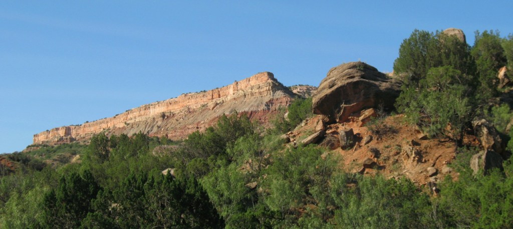
We walk to a vista and get somewhat oriented. It certainly is no Grand Canyon.
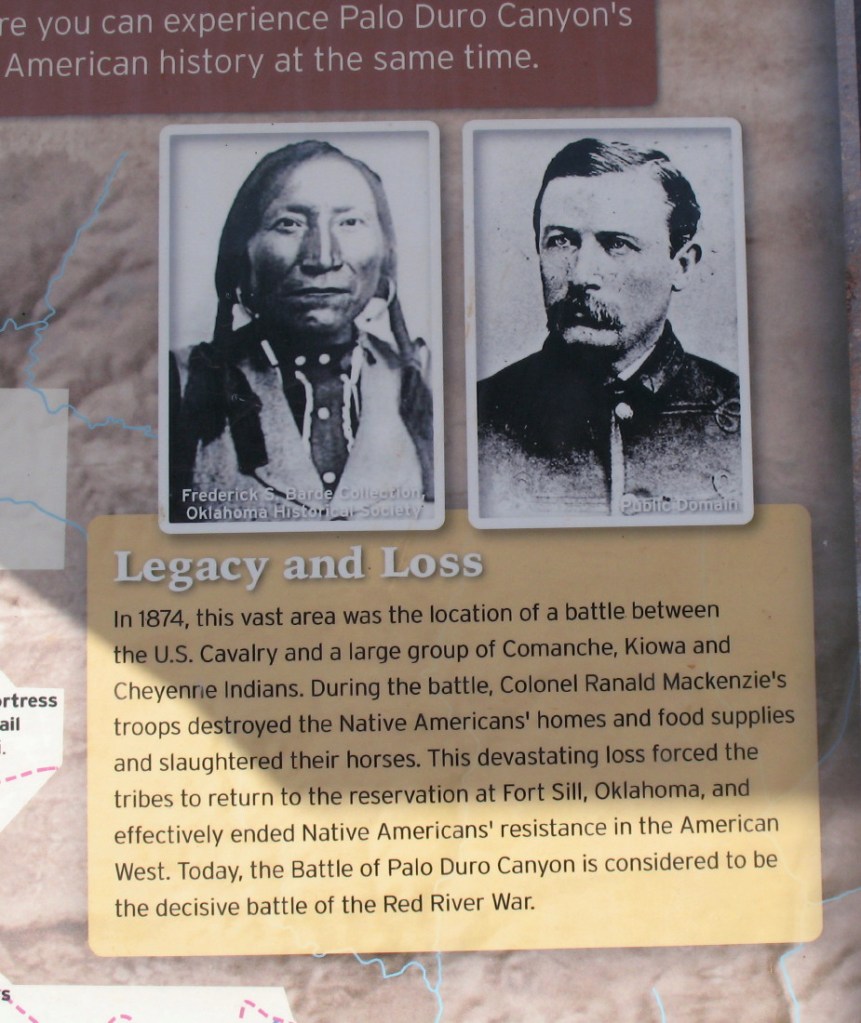
Down the hill on a cliff is the visitor center. Among the curios is a dull museum. I discover a bad documentary about Indians stealing horses, who are off of the reservation. A usual pretense to attack a village. The attempt then, a Wounded Knee, is foiled. The women and children escape, because the warriors in the rocks shoot at the soldiers. There are four dead Indians, but no dead soldiers? There are so many lies in those Indian suppression histories. So they burn all of their stuff, including the winter food, steal 400 horses and massacre the rest of the 1000 horses. The Indians are forced to the reservation by starvation. My embrace of this place is mired.
It is a fun geological spot. There is a little Sedona, a bit of painted desert, and a tad of Mogollon Rim. It is wide, but how this is second only to the Grand Canyon, has to be a “bigger in Texas” myth.

Plans change:
We take off to see how to get around the trail issue. I did have plans to go up a wash in stealth, or hike a creek-side equestrian trail.
I had that plan to use a side canyon to hike, a small sandy draw, with steep walls. That plan is washed away. It would be good on another day. Bugs also discourage the hike up the wash. The park service is patrolling the trailheads to discourage use, as well.

We continue our exploration of the canyon’s tourist road. I desperately want to get out and stretch and hike, thinking that I can find a way to sneak a good walk in this afternoon.
We come across a parking lot with no identifiable markings as a trail. It is empty. There is an opening in the brush that looks like a trail of some sort. It won’t put us out to take a couple of minutes to look. It is a trail down to the creek actually around here called a river. The water is flowing, but there is an unstable bank. It is brown muddy, not a place to swim.

Around us, the brush has been crunched under the overflowing flooding earlier. Much of this valley was obviously turned into a river, jumping its banks.
After walking a hundred feet or so, we find that this is attached to an actual riverside trail, which is probably coming from some trailhead upstream.
We have begun walking down the trail. Curious, I’d like a taste of the nature of the trails around here.
There is a great deal of heat this afternoon, so there isn’t likely to be anyone out here, I figure. I rid myself of my kilt and undo a few buttons, for starters. I still have no idea where we are heading.

My kilt soon takes on a new use. There are biting flying bugs. I use it to swat away the stinging pests. We walk faster.

We soon find the trail has flooded dips in it. To avoid sloshing through mud, we would have to walk around them trampling the precious vegetation and degrading the trail even more. Out of respect and consideration, we stop and turn around.
Where the two trails intersect, there is a chance to touch the water. The steep eroded six foot cliff is replaced by a slope. The red water is pleasant. I wonder if it is the Red River’s head waters.

Looking to drive to the end of the loop and then to the camp, we find the road is buried in silt. A grader has pushed it off to the side like a channel.

We are eventually stopped by a road block.
There are some fun geological experiences in this park. We stop at a couple. Most are surrounded by camping and picnic areas. It is difficult to walk nude. My kilt goes on and off, on and off.
Unexpected Opportunity:
We see a cave up atop a cliff. A trail of debris leads up to it. There are a couple of cars parked down here on the road. One is leaving. We decide to follow our noses up there.

As we gain elevation, I see that we have a vantage out over the valley. There is enough to see and hear anyone coming, but bicycles.

We had thought that this would make any nudity difficult because we would be seen from the road, but it is to our advantage instead.

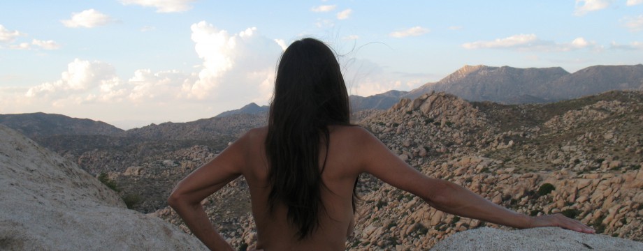
With the other couple leaving, we have undressed. It feels wonderful naked and bodies free again. The fun formations will be a camera opportunity.

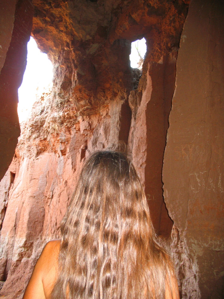
We climb higher and into a fascinating cave. The rains have eroded the walls creating a silo-like tube of silty rock.
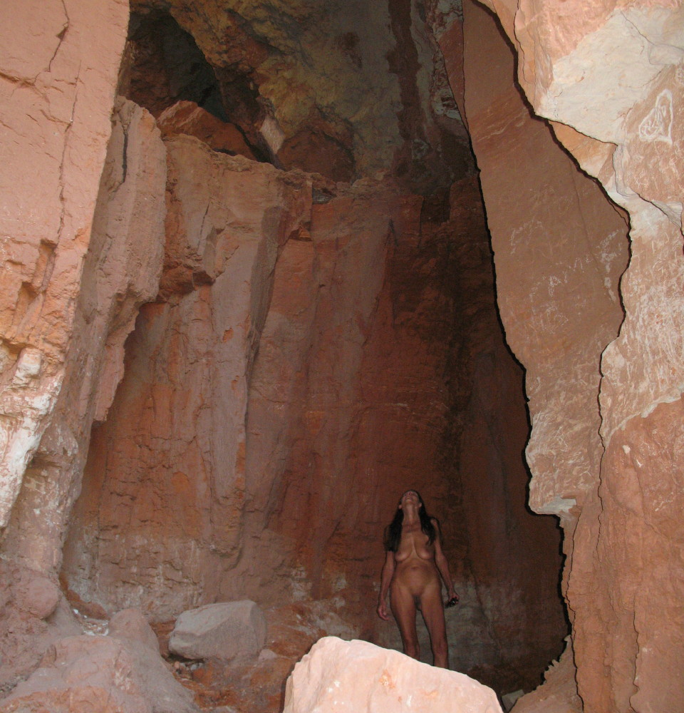
We see the light above where a stream flows through when it rains.

It is nice and shady up here, actually cool without clothes, a respite. Ninety to 100 degree temperatures with humidity from floods and trapped air in the valley have made this canyon unpleasant. We both agree that it feels so good in here, that we don’t want to get dressed again.

Two cars pass by out on the road. We are undetected.
Plan “B”…Nope:
We continue to wander the park in the car, getting out when there is nobody looking and something beautiful appears. The colors in the rock is always fun.

The lizards are rich in color and cocky little folk. Mating season is upon them.

My other option for a nude hike was to be the equestrian trail that leads away from the campers along the creek, or river. I had better expectation for the equestrian facilities. They have seen little use. The camping area is empty for good reason; it is just a dirt lot with a few mesquite.
We park and make our way down the trail. There is no one around. I slip off my kilt and DF her sundress, but very soon, we are surrounded by overgrown river brush, much of it abrasive. It is filled with blind steps, which could harbor snakes. It might be passible on horseback, if the horse didn’t get attacked.
This is after the summer rains. I would figure that the trial would be more pleasant in the spring when the growth is less invasive, but not today.

I walk back to the car nude, but soon another car has me hiding behind its door.
Campground Strategies:
We are now in a busy crowded camping area, with public restrooms. The generators aren’t as loud as this morning. When they stop it is more pleasant. There are some bushes to pitch the tent with the top cover off. When the sun goes down, we can lie and watch the stars in this remote dark sky, our nudity on a warm night undetected.
Before sundown, we take a leisurely walk to the glamping area adjacent to this campground. Large pavilion tents of vega logs are erected there for rent. In the back of one, we see an air conditioner. We could use that right now.

The fully outfitted porch has a charm as well.
The sun will soon go down and a quick shower will help. Naked under the stars and a bug screen will be a pleasure.
Red rock cliffs are aglow as sun falls behind canyon walls to the west. It is like diner with a movie.
Conclusions:
The draw is doable. If you park at Capital Park Trailhead and then take Juniper Trail-Cliffside south, it will intersect a wash. Double back and up the wash. It will meander with steep walls on either side. You can see this on a satellite photo on Google Maps. It looked good from the road. Sadly, we missed it.
There is hiking and I wouldn’t’ expect many on many of the longer trails. If you can stand doing group camping, or keep clothes on.

I’d recommend this as a stop certain times of the year. It can be extremely hot in the summer and cold in the winter. It is a nice spot to rest in the middle of that long truck across the deserts to get to the forests. It is a nice place, almost Arizona, but we arrived on the wrong day.

I am on the forum of FreeRangeNaturism.com often, if you would like to converse.
© The owners of TheFreeRangeNaturist.org as of the year 2015 declare. Unauthorized use and/or duplication of this material without express and written permission from this site’s author and/or owner is strictly prohibited. Excerpts and links may be used, provided that full and clear credit is given to TheFreeRangeNaturist.org with appropriate and specific direction to the original content.

Pingback: Palo Duro Canyon | EcoNudes